FJDynamics create for a better world

With R&D and operations centers in Singapore, Sweden, Hong Kong (China) and Chinese mainland, FJD is dedicated to simplifying workflows, enhancing productivity, and democratizing advanced technology for industries such as agriculture, digital construction and surveying across the world.

FJDynamics
FJDynamics is on a mission to empower the most labour-intensive industries with accessible technological solutions. With R&D and operations centres in Singapore, Sweden, Hong Kong (China) and Chinese mainland, FJD is dedicated to simplifying workflows, enhancing productivity, and democratising advanced technology for industries such as agriculture, digital construction and surveying across the world
Our Products

Products And Customized Solutions To Ensure Your Market Success

FJD Slam Laser Scanner

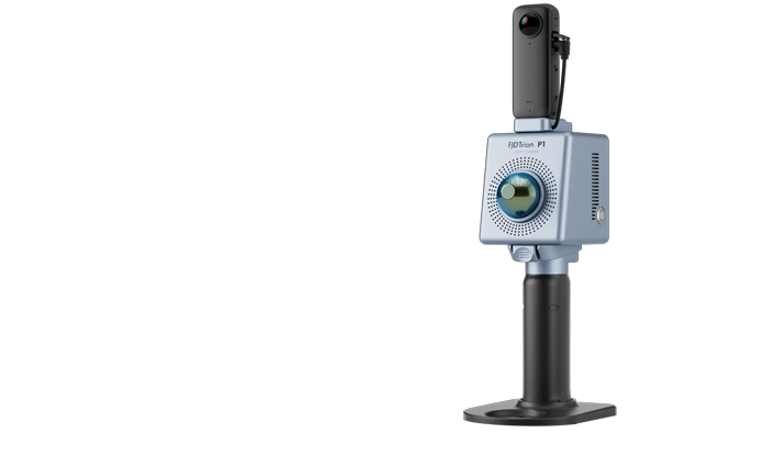
FJD Trion P1 Laser Scanner

P1 FDJ Trion
EASY REALITY CAPTURE
Whether you are a seasoned laser scanning professional or just 3D-curious, a walk around the site with the P1 lets you digitise your environment quickly and accurately.
spec-fjd-trion-p1-laser-scanner

Wherever you go, the P1 can capture what you see. Map the environment with intricate details inside and outside, from ornate architecture to hidden infrastructure, from forensic evidence to urban vegetation analysis. Powerful SLAM technology enables the P1 to work in direct sunlight or even at night, in locations that may be inaccessible with traditional methods.

Generate deliverables such as contour maps, distance, area, and volume calculations, floor plans, tree and forest analyses, and 3D models like BIM, DEM, and 3D mesh.

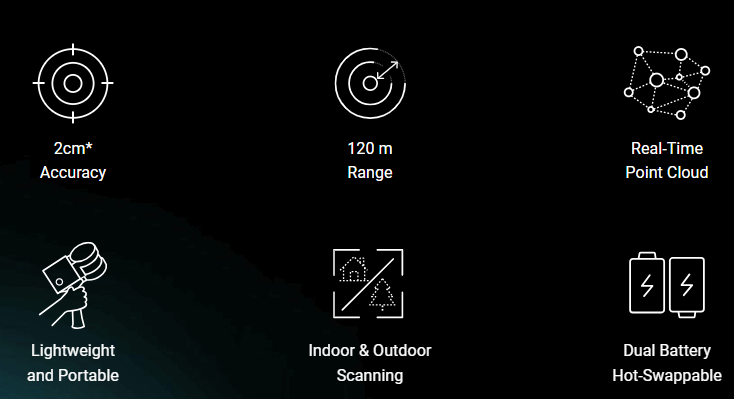
FJD Trion S1 3D Laser Scanner

S1 FJD
fjd s1 hasil scan
A NEW WAY TO SCAN THE WORLD
Powered by a leading SLAM algorithm, the S1 builds your reality as you scan. Capture indoor and outdoor environments as you walk, and view real-time point clouds on your mobile device. See your surroundings come to life with every step, so you don’t miss any details.
spec-fjd-trion-s1-3d-laser-scanner

Reliable Accuracy

Scan a 100 m²/1,000 sq ft area in just 2 minutes, and achieve 2 cm of relative accuracy with post-processed reconstruction models.

Long-Range Measurement

Featuring a built-in LiDAR 3D scanning technology, the S1 allows you to capture precise measurements of complex objects and shapes in various dimensions and generate 3D models in one scan.

FJD Trion S1 3D Car Mount

fjd-carmount
CAPTURE INDOOR AND OUTDOOR ENVIRONMENTS AS YOU WALK
owered by a leading SLAM algorithm, the S1 builds your reality as you scan. Capture indoor and outdoor environments as you walk, and view real-time point clouds on your mobile device. See your surroundings come to life with every step, so you don’t miss any details.

Reliable Accuracy

Scan a 100 m²/1,000 sq ft area in just 2 minutes, and achieve 2 cm of relative accuracy with post-processed reconstruction models.

Long-Range Measurement

Featuring a built-in LiDAR 3D scanning technology, the S1 allows you to capture precise measurements of complex objects and shapes in various dimensions and generate 3D models in one scan.
Combine the carmount with RTK to showcase exceptional data-gathering capabilities and generate precise geo-referenced point clouds with centimetre-level accuracy.
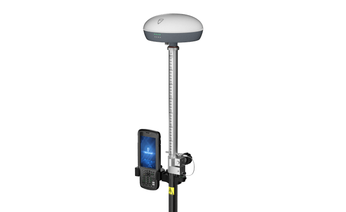
ATG is a smart way to continuously monitor the FUEL Level in storage tanks. It can be installed in Underground/Stationary tanks or Mobile Bowsers/Tankers with FUEL LEVEL and TEMPERATURE visible continuously on the Online portal with Graphical representation. In case of underground tanks Water level as well as density of fuel can also be monitored to identify the dilution of the fuel quality. ATGs are the best way to monitor and Track the total fuel stock with-in company and at each site.

FJD GNSS

FJD Trion V1T Base

v1t base
MAKE NAVIGATION MORE ACCURATE
The FJD V1 Base Station is a lightweight GNSS RTK receiver that supports all constellations and frequencies. With strong anti-interference capabilities, it provides fast and accurate positioning even in harsh environments.

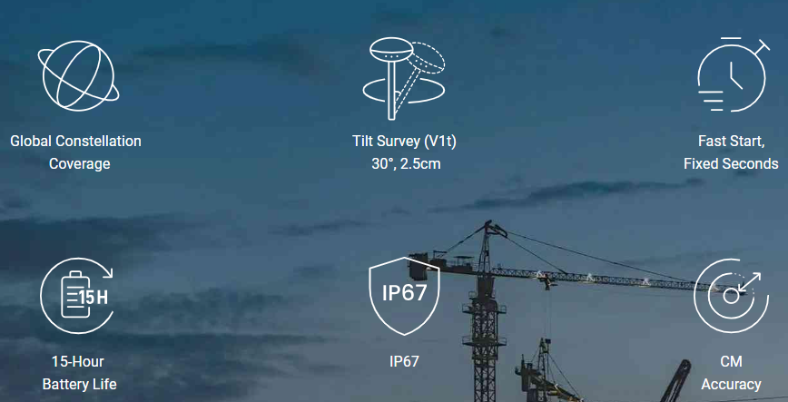
With an FJD External Radio, the V1’s working range can reach up to 30 km in optimal conditions.

FJD Trion V1T Rover

fjd-trion-v1-rover1
A NEW WAY TO MEASURE THE WORLD
FJD Trion V1 series, a versatile and lightweight GNSS RTK receiver, can quickly deliver accurate positions in harsh environments with global signal coverage. V1t, the advanced version, is engineered with an Inertial Measurement Unit (IMU) that frees you up from watching and levelling the bubble when measuring.
spec-fjd-trion-v1t-rover

FJD Trion Field Controller E200

E200 controller streamlines your construction workflow with its study and durable housing, industrial-grade three proofings, and a high-brightness display that allows for sunlight readability.

  • 5-inch screen
  • 7000 mAh, 24h battery life
  • CPU 2.4Ghz
  • Memory 4+64 GB
  • USB- Type C, OTG Support
  • 1.5-meter drop test survivor
  • IP67

FJD Trion V10i

v10i-trion
CAPTURE MORE, WORRY LESS
Grab the V10i and get measuring. Integrating an OLED screen, IMU, and two cameras, the V10i gives us a next-level productivity boost. The AR Stakeout gives you real-time visual guidance on stakeouts. The Visual Measure achieves the measurement of hard-to-access locations. An OLED screen will bring a new interactive experience for Surveyors.

The V10i supports the Tilt Survey of 60 degrees. We don’t need to hold the survey pole upright when measured, which improves the efficiency of the measurement. When we meet some positions where we can’t hold the pole upright, the Tilt Survey function will help you solve it easily.

E600 controller

Slim and large screen ergonomic controller.

  • 720*1440, 5.5-inch large screen
  • 7700mAh, Fast Charge
  • CPU 8 cores 2.0GHz
  • Memory 3+32 GB
  • 13 MP camera with auto-focus
  • 1.5-meter drop-proof & IP67
  • BT5.0 (BLE), NFC, WiFi, 2G,3G&4G

External Radio

fjd radio
GO WIRELESS, GO EASY
Grab the V10i and get measuring. Integrating an OLED screen, IMU, and two cameras, the V10i gives us a next-level productivity boost. The AR Stakeout gives you real-time visual guidance on stakeouts. The Visual Measure achieves the measurement of hard-to-access locations. An OLED screen will bring a new interactive experience for Surveyors.

The V10i supports the Tilt Survey of 60 degrees. We don’t need to hold the survey pole upright when measured, which improves the efficiency of the measurement. When we meet some positions where we can’t hold the pole upright, the Tilt Survey function will help you solve it easily.

Request for Quotation

Please enable JavaScript in your browser to complete this form.

Office

Menara 165, Lantai 3, Jl. TB. Simatupang Kav. 1, RT.3/RW.3, Cilandak Timur, Pasar Minggu, Jakarta Selatan, Daerah Khusus Ibukota Jakarta 12560

Call Us

For IoT Solutions: +62811 1300 4220
For Geospatial Solutions: +62812 8030 8333